Adventure, mysticism, and nature at 2,810 m altitude
Introduction
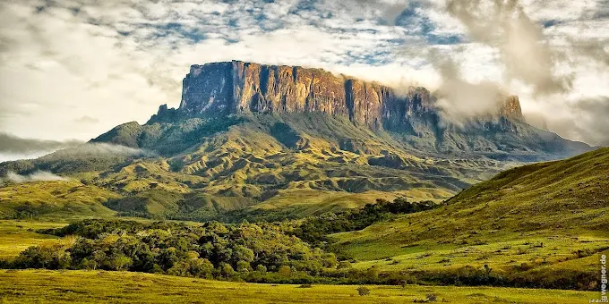
Monte Roraima National Park is one of South America’s most spectacular and enigmatic destinations. Nestled on the tripoint border of Brazil, Venezuela, and Guyana, this majestic tabletop mountain, or tepui, rises to an impressive 2,810 meters above sea level. Its protected Brazilian area offers an iconic itinerary for those seeking adventure, contemplation, and deep connection with nature. This article explains why this geological treasure should top your travel list.
1. What is Monte Roraima National Park
Located in Uiramutã, the northernmost municipality of Roraima, the park was established by federal decree on June 28, 1989, covering some 116,748 hectares. . Encompassed within the Raposa Serra do Sol Indigenous Territory, its mission is to protect unique ecosystems, support scientific research, and offer responsible ecotourism opportunities.
The park includes a wide variety of environments: savannas, high-altitude forests, plateaus, valleys, rivers, and waterfalls. Elevations range from 920 m to approximately 2,780 m, with the characteristic tepui cliffs and dramatic escarpments. . Beyond Mount Roraima itself, the Pacaraima mountain complex includes other notable peaks like Serra do Sol.
2. Legends and mysticism of Monte Roraima
In the mythology of the Macuxi and Pemon peoples, Mount Roraima is the “Home of the Gods.” Stories tell that the mountain emerged when heaven touched the earth, dissolving the boundary between the human and the sacred. This spiritual dimension inspires awe in visitors, evoking the feeling of encountering the inaccessible.
Geologically, the tepui consists of Precambrian rocks—more than 2 billion years old—making it a living relic of Earth’s earliest eras. . The dramatic rock formations, sheer 1,000-meter cliffs, and cubic tepui structures create extraterrestrial landscapes—ideal for those in search of unparalleled experiences. The “Lost World” by Sir Arthur Conan Doyle was famously inspired by expeditions to this region. .

3. How to reach the park
Via Brazil
The journey begins in Boa Vista, the capital of Roraima. From there, travelers follow BR‑174 to Pacaraima, a small town on the Venezuelan border. In Pacaraima, authorized agencies and guides are hired. The route continues by 4×4 vehicle on unpaved roads to the village of São Francisco (Uiramutã)—the trailhead.
Via Venezuela or Guyana
Entry from Venezuela (through Santa Elena de Uairén and Gran Sabana) or from Guyana is possible, creating international trekking options. However, most tourists choose the Brazilian route for logistical ease.
Guides and permits
Trekking is allowed only on authorized paths. Certified indigenous guides—often Pemon or Macuxi—are mandatory. Permits and fees collected by ICMBio and local agencies also support conservation and pay indigenous communities.
4. Trails and key attractions
Trail to the summit
The standard trek takes 6 to 8 days, with overnight campsites at the base and on the plateau. Hikers cross savanna, forest, and natural rock ramps, camping each night with panoramic views.

Vale dos Cristais (Crystal Valley)
On the plateau, this valley is scattered with translucent quartz crystals formed by millennia of wind and rain—a breathtaking natural marvel.
Triple Frontier Point
At the summit lies the tripoint boundary marker (Brazil–Venezuela–Guyana). From this vantage, hikers can stand in three countries simultaneously—a powerful blend of geography and symbolism.
Natural Jacuzzis
Rock-carved pools filled with clear water offer refreshing dips with dizzying views over the cliffs below.
Gladys Lagoon & Maverick Rock
The plateau features small lakes like Laguna Gladys, alongside the impressive Pedra Maverick, reaching the full altitude of approximately 2,810 m.

5. Flora and fauna
Unique and endemic species
The park is home to carnivorous plants like Heliamphora and Drosera, bromeliads like Brocchinia, highland orchids such as Ecyclia, mosses, fungi, and other surprising high-altitude flora.
The plateau is also the only habitat of the toad Oreophrynella quelchii, a tiny creature (2–3 cm) classified as vulnerable by the IUCN. . Additionally, rare bird species like the Roraiman antbird and antwren inhabit these heights.
Wildlife diversity
In lower elevations, diverse Amazonian wildlife is present, including mammals, turtles, and birds—an estimated 114 species have been recorded in the Cotingo River basin.

6. Responsible tourism and park rules
- Follow ICMBio regulations: camp only in designated areas, carry out your trash, use stoves instead of fires, and do not collect plants or rocks.
- Hiring certified guides is mandatory and essential for logistics and safety.
- Trekking supports indigenous communities (Pemon, Macuxi, Ingarikó) through local guide services, porters, and craft purchases.
- The park’s management is a cooperative system between ICMBio and FUNAI; since 2005, joint governance has resolved overlapping territorial issues.
7. What to pack for the expedition
- Gear: tent, sleeping bag, sleeping pad, headlamp, portable stove
- Clothing: thermal layers, windbreaker, rain jacket, sturdy boots
- Health: insect repellent, sunscreen, basic first aid kit, water purification tablets
- Hydration tools: water bottles and filters
- Physical prep: cardiovascular fitness and cold-weather acclimation
- Extras: trekking poles, sunglasses, hat, gloves

8. Suggested itinerary
- Day 1: Arrive in Boa Vista, travel to São Francisco (Uiramutã)
- Day 2: Hike to Tek River (initial campsite)
- Day 3: Trek to base camp beneath the cliff walls
- Days 4–5: Ascend to the plateau, explore terrain
- Days 6–7: Plateau excursions across Crystal Valley, Gladys Lagoon, Jacuzzis, Maverick Rock, and the tripoint
- Day 8: Descend from the plateau to base camp
- Day 9: Return trek to Tek River
- Day 10: Return to Pacaraima and Boa Vista
This 8- to 10-day plan allows proper acclimatization and full enjoyment of landscapes and ecosystems—despite the physical demands and weather challenges.

9. Inspiring curiosities
- The tepui is considered among the largest plateau summits globally, covering roughly 33 to 50 km².
- Annual rainfall can reach a staggering 4,000 mm, creating micro-caves and subterranean streams.
- The first documented ascent was in 1884 by a British expedition led by Everard F. im Thurn, inspiring generations of explorers and authors.
- Around 3,500 people visit the park annually, mostly South Americans, with approximately 38% from Europe.
Final Words
Monte Roraima National Park is more than a tourist destination—it is a portal to another era, where science, myth, and adventure converge within ancient rock formations. The mountain’s raw power, unique biodiversity, and deep-rooted mysticism create journeys that transform the soul.
If you’re seeking an experience beyond guidebooks—one that transcends maps and paths while revealing the poetry of Earth—get ready to ascend. Monte Roraima waits with its cliffs, primeval stones, and skies that touch the stars. Plan your expedition now: this is a journey that changes lives.